Cadiz Bay
Cádiz Bay is a large coastal lagoon located in southwestern Spain, along the Atlantic coast of Andalusia, near the city of Cádiz. Sheltered by a system of sandbars and low-lying coastal plains, the lagoon is fringed by salt marshes, tidal creeks, and mudflats. It features broad intertidal areas that support extensive seagrass meadows, primarily composed of Zostera noltei and Zostera marina. These meadows are particularly prominent in the inner parts of the lagoon and are exposed during low tide. As shown in Figure 1, the area analyzed in this study covers more than 7 km². Has water level varies greatly between images, the intertidal mask has been drawn in a conservative way, overestimating the actual intertidal area. Saltmarsh areas are not concidered for this study and have therefore been removed from the mask.
For this site, a time series of the Sentinel-2 missions has been used to monitor the seagrass meadow since 2017 (Table 1). This work was published by Zoffoli et al. (2021). The present work updates the time series from Zoffoli et al. (2021) by incorporating newly available images and computing additional metrics (see Methodology).
Date | Capteur | Date | Capteur | Date | Capteur |
|---|---|---|---|---|---|
juin 26, 2017 | Sentinel-2 | mai 26, 2020 | Sentinel-2 | mai 11, 2023 | Sentinel-2 |
mai 17, 2018 | Sentinel-2 | mai 10, 2021 | Sentinel-2 | juillet 09, 2024 | Sentinel-2 |
juin 21, 2019 | Sentinel-2 | mai 06, 2022 | Sentinel-2 |
List of Satellite images used to follow the meadows in Cadiz Bay
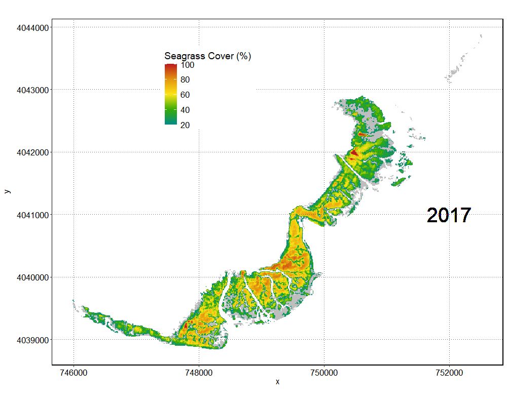
Figure 2 is show the evolution of the Seagrass Cover over time, since 20175. The minimum density was recorded in 2023 with 44% of average cover, while the maximum density has been recorded in 2022 with 59% of average cover.
Historical seagrass patches of the meadow
Figure 3 shows the number of consecutive years, starting in 2024, during which each pixel maintained a Seagrass Percentage Cover (SPC) above 50% every single year. The most consistent part of the meadow is located near the the old military area, where the seafloor has shown SPC values above 50% every year since the beginning of the time series in 2017. Haro et al. (2021) reported the presence of Caulerpa species in this area, so it is possible that this consistently dense patch may be Caulerpa rather than seagrass. Ground-truthing is necessary to confirm the true nature of this vegetation. Some areas near the sampling location also show consistently high SPC values above 50% since 2017. In contrast, the southernmost part of the study site shows more variability, with less consistent SPC values over time.
Year of the maximum of cover
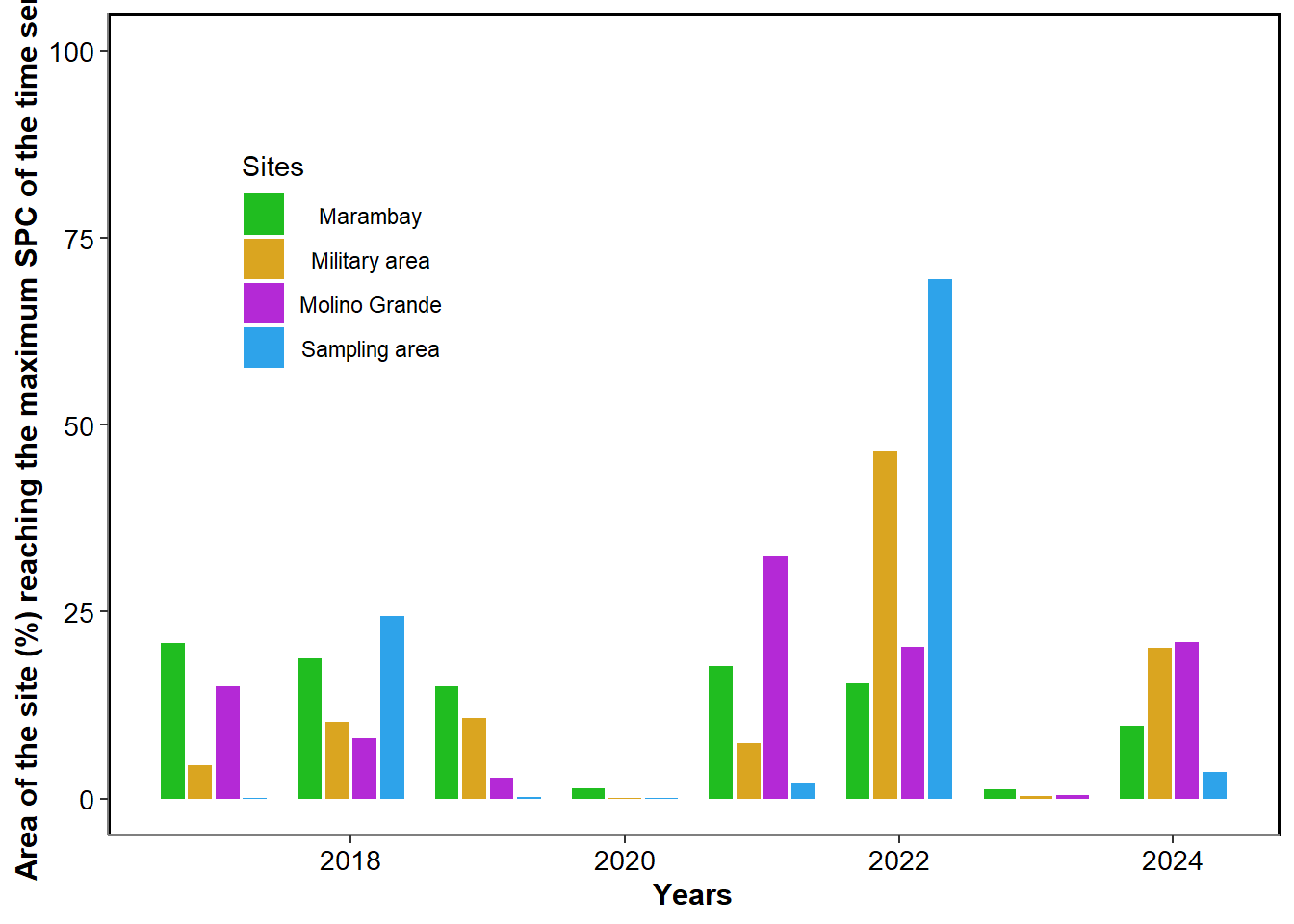
Figure 4 shows, for each pixel, the year in which it reached its maximum Seagrass Percentage Cover (SPC). At the sampling location, approximately 70% of the area reached its maximum SPC in 2022, and 25% in 2018 (Figure 5). Across all sites, almost no pixels reached their maximum values in 2020 or 2023.
Rate of decline since the date of maximum
Figure 6 shows the rate of decline in seagrass cover, expressed as percent cover lost per year, since the year of maximum SPC indicated in Figure 4. On average, the meadow has been losing 3.26% of its seagrass cover per year since reaching its maximum.
Amount of time above 50% since the start of the time serie
Figure 7 shows the proportion of time each pixel maintained an SPC value above 50%. The most consistent area is the military zone, which has persistently shown SPC values above 50%. The sampling site displays more variable coverage, with the inner part of the meadow more consistently maintaining high SPC values. In contrast, the northernmost section of the sampling area shows a lower frequency of high seagrass coverage. Finally, the meadow in Marambay shows high SPC values less frequently than the other sites.